Anthropisation and spatio-temporel dynamics of land use in the Lisala region between 1987 and 2015
Authors
Julien BWAZANI BALANDI, Jean-fiston MIKWA NGAMBA, Sylvain KUMBA LUBEMBA, Pitchou MENIKO TOHULU, Alphonse MAINDO MONGA NGONGA, Jean-pierre MUKANDAMA NDOLA NDOLA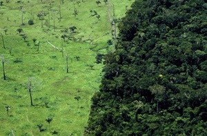
Key Information
Journal
Published in Vol. 8 No. 4 (2020) of Moroccan Journal of Agricultural and Veterinary Sciences.
Multidisciplinary journal that publishes original research articles and literature reviews in the fields of agriculture, agronomy, rural engineering, topography, forestry, horticulture, food, nutrition, animal husbandry and veterinary science (online-ISSN: 2550-4401, print-ISSN: 2028-991X). Indexed by DOAJ, Google Scholar, Articles DOAJ, Mirabelle, ROAD, WorldCat
About the Journal
Abstract
The general objective pursued in this study is to determine the dynamics of the forest landscape between the years 1987, 2000 and 2015 in the territory of Lisala, in the Democratic Republic of Congo. To carry out this study, remote sensing and GIS were used. The dynamics were determined from land cover maps, deforestation and change rates, indices of spatial structure and spatial transformation processes. It appears from the results that forest classes occupied 94.2% of the territory in 1987; 88.6% in 2000 and 86.8% in 2015, for a deforestation rate of 0.4% between 1987 and 2000; 0.13% between 2000 and 2015. Dissection and suppression are identified respectively in the dense forest wetland and secondary forest for the period from 1987 to 2000. The diachrony 2000-2015 is marked by aggregation in dense forests and suppression in secondary forests. The dense forest and the secondary forest constitute the main providers of space for the anthropic classes. Thus, sustainable development policies focused on urbanization and forest management must be initiated with a view to reversing current trends.
Keywords: Anthropisation, Dynamics of the Forest Landscape, Remote Sensing, and Lisala
References
Details
License

Revue Marocaine des Sciences Agronomiques et Vétérinaires est mis à disposition selon les termes de la licence Creative Commons Attribution - Pas d’Utilisation Commerciale - Partage dans les Mêmes Conditions 4.0 International.
Fondé(e) sur une œuvre à www.agrimaroc.org.
Les autorisations au-delà du champ de cette licence peuvent être obtenues à www.agrimaroc.org.