Automatic extraction of irrigated areas in the Gharb region by image-based image analysis of Landsat 8 images
Authors
Bouchra El Houda LAMHAMEDI, Nassima JNAH, Imane SEBARI, Zouhair BENBAHRIA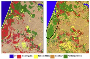
Key Information
Journal
Published in Vol. 5 No. 2 (2017) of Moroccan Journal of Agricultural and Veterinary Sciences.
Multidisciplinary journal that publishes original research articles and literature reviews in the fields of agriculture, agronomy, rural engineering, topography, forestry, horticulture, food, nutrition, animal husbandry and veterinary science (online-ISSN: 2550-4401, print-ISSN: 2028-991X). Indexed by DOAJ, Google Scholar, Articles DOAJ, Mirabelle, ROAD, WorldCat
About the Journal
Abstract
Morocco has made enormous efforts in the irrigation field. However the lack of information regarding the precise location and delimita-tion of the irrigated areas is increasingly affecting farmers’ monitoring and control. The main objective of this study is to evaluate the contribution of the object-based image analysis approach for automatic extraction of irrigated areas, especially those out of the officials irrigated perimeters. We worked on two Landsat 8 images of the Gharb region. Three methods of classification have been carried out and evaluated according to the object-based approach. For the first two methods, we have created and implemented a series of membership rules, that aim, through various attributes (NDVI and temperature), to discriminate the objects of interest. For the third method, we used the nearest neighbor interpolation to establish a land cover map of the area of study. The results of this study are very promising. The irrigated areas were successfully extracted at 88.5 %. The superposition of the extracted areas with the boundary of the official irrigated perimeter made it possible to detect and locate irrigated areas outside this perimeter in the Gharb region. This will contribute to a better monitoring and control of the irrigation methods and the water consumption of the farmers in this region.
Keywords: Irrigated areas, automatic extraction, object-based image analysis, Landsat 8 images, NDVI, temperature.
References
Details
License

Revue Marocaine des Sciences Agronomiques et Vétérinaires est mis à disposition selon les termes de la licence Creative Commons Attribution - Pas d’Utilisation Commerciale - Partage dans les Mêmes Conditions 4.0 International.
Fondé(e) sur une œuvre à www.agrimaroc.org.
Les autorisations au-delà du champ de cette licence peuvent être obtenues à www.agrimaroc.org.