Integrated environmental analysis using GIS for rational planning of conservatory land management: Application in the Dhar Souk region (Taounate Province, Morocco)
Authors
Mustapha LOUKILI, Yassine IHISSOUFiles
Key Information
Journal
Published in Vol. 4 No. 1 (2016) of Moroccan Journal of Agricultural and Veterinary Sciences.
Multidisciplinary journal that publishes original research articles and literature reviews in the fields of agriculture, agronomy, rural engineering, topography, forestry, horticulture, food, nutrition, animal husbandry and veterinary science (online-ISSN: 2550-4401, print-ISSN: 2028-991X). Indexed by DOAJ, Google Scholar, Articles DOAJ, Mirabelle, ROAD, WorldCat
About the Journal
Abstract
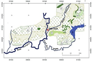
The objective of this work is the realization of a map spatializing the land use and management actions, in the context of sustainable development. It was obtained based on a diagnosis of the natural environment that enabled the analysis and identification of constraints to the development of an area in Dhar Souk (Province of Taounate). The methodology consists of an analysis of data collected through surveys of farmers and field surveys. Thus spatial data were organized in the form of soil-related thematic information layers, land use, geology, forms of erosion and DEM. The integration of these thematic layers and other data in the GIS and cross allowed the realization of a management board and land development. This may serve as a basic document in the choice of guidelines for operations of the development will be taken by managers and development actors of the area.
Key-words : Map of land use and management, GIS, Soil and water conservation, Dhar Souk, Taounate, north of Morocco
References
Details
License

Revue Marocaine des Sciences Agronomiques et Vétérinaires est mis à disposition selon les termes de la licence Creative Commons Attribution - Pas d’Utilisation Commerciale - Partage dans les Mêmes Conditions 4.0 International.
Fondé(e) sur une œuvre à www.agrimaroc.org.
Les autorisations au-delà du champ de cette licence peuvent être obtenues à www.agrimaroc.org.