Mapping the dynamics of land use in the INERA-Yangambi concession in the Democratic Republic of Congo
Abstract
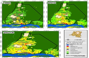
The DR Congo has vast tracts of forest that contribute to the well-being of the local population and to climate regulation. However, for several decades now, these forests have been subject to strong anthropic pressure, resulting in deforestation and the fragmentation of these forest ecosystems. The Yangambi region, one of the richest forest regions in DR Congo, is also suffering from the same situations related to deforestation and habitat fragmentation. This is why the aim of this study is to carry out a cartographic and quantitative analysis by remote sensing of the dynamics of land use in the INERA-Yangambi concession. The classification by object with the supervised approach of Landsat images allowed to characterize the land cover in three dates (1990, 2010 and 2018). For study purposes, six land cover classes were selected according to the realities on the ground: built/bare ground, agricultural complex, wasteland, plantations, secondary forest and primary forest. The analysis of landscape dynamics and fragmentation was carried out by means of transition matrices and certain indices of the spatial structure of the landscape. The results showed that there was a change in land use over a period of 28 years. We also found that forest formations (primary forest and secondary forest) have experienced a significant regression in favour of anthropogenic classes (built/bare ground and agricultural complex), with an annual deforestation rate from 1990-2010, 2010-2018 and 1990 and 2018 estimated at 0.29%, 0.96% and 0.89% respectively. It should also be noted that there has been a progressive fragmentation of forests (primary and secondary) evidenced by the continuous increase in the number of patches, the decrease in the density of patch perimeters and the impressive decrease in their average area. Also, the average distance between two neighbouring patches has increased, indicating an increased isolation of patches. These results suggest the need for a management plan for the sustainable management of the concession and its natural resources.
Key words: Landscape dynamics, land use, deforestation, landscape fragmentation, remote sensing, spatial structure, INERA-Yangambi
Downloads
Downloads
Published
Issue
Section
License

Revue Marocaine des Sciences Agronomiques et Vétérinaires est mis à disposition selon les termes de la licence Creative Commons Attribution - Pas d’Utilisation Commerciale - Partage dans les Mêmes Conditions 4.0 International.
Fondé(e) sur une œuvre à www.agrimaroc.org.
Les autorisations au-delà du champ de cette licence peuvent être obtenues à www.agrimaroc.org.